GlobalScout app for iPhone and iPad
4.6 (
2096 ratings )
Productivity
Navigation
Developer:
Richard Kurz
6.99 USD
Current version:
1.7.8, last update: 7 years ago
First release : 23 Dec 2010
App size: 3.79 Mb
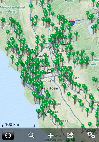
GlobalScout the ultimate GIS tool! The hub for all your GEO data. It can handle ridiculous amounts of data, hundreds of tracks and (hundred) thousands of waypoints or POIs for all your favorite locations. Take all your geo data with you. Record, manage, search and edit them on the road.
Plan your trip with GoogleEarth, download your favorite POIs from the internet. Use the same files you use on your navigation system (GPX, KML and KMZ) and upload everything to your iOS device.
* Universal App for iPhone & iPad *
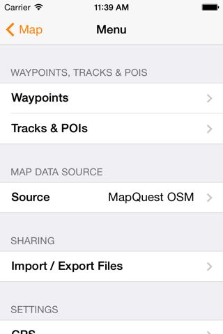
Features:
► Upload, record, manage and edit hundreds of tracks and (hundred) thousands of waypoints.
► Send waypoints or Points Of Interest to your Navigon, TomTom or Sygic navigation app.
► Import and export GPX, KML and KMZ files using iCloud Drive, email, the integrated web server, iTunes File Sharing, or Document Providers like Dropbox, OneDrive, Google Drive, Box, Transmit etc.
► Export GPX, KML or KMZ files to other apps.
► Share waypoints, POIs or your current location.
► Apple Maps integration.
► Offline map cache allows you to load maps once and view them later without an internet connection. Save data roaming charges abroad.
► Use custom map server.
► Moving map.
► Auto rotating map (requires a magnetometer).
► Navigate to waypoints using bearing, heading and distance.
► Measure distances on maps.
► Display coordinates in D, DM or DMS. Use metric, imperial, or nautical units.
► EGM2008 altitude correction.
► Track statistics.
► Stable and fast, powerful not colorful.
We hope you like GlobalScout. If you do, please rate us in the App Store. If not, please write to us before leaving a negative review, as we can often help with your problem and with your feedback we can further improve this app.
All default data like maps, routes and search results are provided by OpenStreetMap, MapQuest, GeoNames or Wikipedia.
Important: Continued use of GPS running in the background can dramatically decrease battery life.
Pros and cons of GlobalScout app for iPhone and iPad
GlobalScout app good for
Used it for importing a two-week-motorcycle-tour through Norway including dozens of POIs and 3,000 km tracks from Google Maps, then pre-loaded most of southern Norway with decent details and we had no troubles with finding our way for the whole time. Very stable, very precise. Thumbs up!
Still my favorite mapping app. Map display very fast! Nice retina map.
Some bad moments
I just bought this app and it is not opening a simple KMZ file. The app simply doesnt show it on map. It only send you to open in another app, like Google Earth. So the app is useless.
Terrible app. It doesnt even display a map I am looking for an app that displays property lines but I just wasted 6 dollars
Small sized app (2 mb) with big features. Waypoints and poi files import easily whether downloaded from the Internet or made yourself. Extremely stable, hasnt crashed or hung up. Map sets can be pre downloaded for times you will not have coverage. Record tracks and navigate to locations. Listen to music in app. Compass rose with bearing indicator, signal strength indicator, heading, speed, location, and altitude in header. Scale indicated on map. Great navigation app. Easy to set up and use, with lots of settings to customize your experience.
Amazing little app. I imported several thousand POIs into this program and it handled it with no problem.
Easy to add additional map sources, see the forum for details.
If you need a mapping program to handle multiple POIs, get this app.
I LOVE THE FACT THAT YOU CAN IMPORT YOUR GPX/KML FILES WITH THIS APP AND SEE YOUR PAST TRACKS FROM OTHER DEVICES. IT TOOK A LONG TIME TO FIND SUCH A THING. IT DOESNT CRASH EITHER LIKE OTHER GPS APPS, VERY RELIABLE!
This is an exceptional app, powerful, but with a clean, simple interface. I use it primarily for outdoor navigation and mapping of locations and property boundaries. You can input and edit the location of waypoints, organize them into groups, and assign different icons to different waypoint groups. You can input and edit routes, as well as create tracks on the fly. You can pre-load map tiles for offline use and import/export your data to and from other applications. Best of all you can configure your own map data sources from the many free mapservers available on the web, enabling easy switching between vector and raster based topographic maps, satellite imagery and street maps. Other apps have some of these features--this is the only app I have tried with the whole package. Five stars!